Geolocate

Steingaden topographic map

Click on the map to display elevation.

About this map

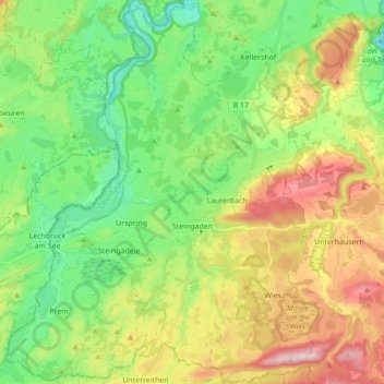
Name: Steingaden topographic map, elevation, terrain.

Location: Steingaden, Steingaden (VGem), Landkreis Weilheim-Schongau, Bavaria, 86989, Germany (47.65504 10.80270 47.77174 10.91947)

Average elevation: 798 m

Minimum elevation: 693 m

Maximum elevation: 1,009 m

Other topographic maps

Click on a map to view its topography, its elevation and its terrain.

Dessau

Germany > Bavaria > Landkreis Weilheim-Schongau > Burggen

Average elevation: 749 m

Tauting

Germany > Bavaria > Landkreis Weilheim-Schongau

Average elevation: 650 m

Fischen

Germany > Bavaria > Landkreis Weilheim-Schongau

Average elevation: 577 m

Gear up for your next adventure:

🔋Lithium AA Batteries - Long-lasting power that performs in extreme cold
💧Hydration Pack - Hands-free hydration system for long hikes
🔭Compact Monocular - One-handed bird watching and trail spotting
👟Sport Hiking Sandals - Breathable footwear for water crossings and camp rest
🔪Outdoor Multitool - Versatile tool for repairs and food prep in the wild

As an Amazon Associate, this site earns from qualifying purchases at no extra cost to you.