Geolocate

Vico d'Elsa topographic map

Click on the map to display elevation.

About this map
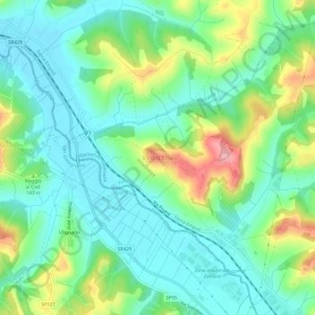
Name: Vico d'Elsa topographic map, elevation, terrain.

Location: Vico d'Elsa, Barberino Tavarnelle, Florence, Tuscany, 50021, Italy (43.49329 11.07688 43.53329 11.11688)

Average elevation: 114 m

Minimum elevation: 70 m

Maximum elevation: 216 m

Other topographic maps

Click on a map to view its topography, its elevation and its terrain.
Barberino di Mugello

Italy > Tuscany > Florence

Average elevation: 495 m

San Casciano in Val di Pesa

Italy > Tuscany > Florence

Average elevation: 230 m

Piazza D'Azeglio

Italy > Tuscany > Florence > Florence

Average elevation: 61 m

Gear up for your next adventure:

🧴Waterproofing Spray - Restore the DWR coating on jackets and tents
🎒Hiking Daypack - Lightweight and durable backpacks for day trips and excursions
🥘Camping Cookware Set - Compact nesting pots and pans for trail cooking
🧢Hiking Hat - Sun-protective and breathable hats for long treks
🔪Outdoor Multitool - Versatile tool for repairs and food prep in the wild

As an Amazon Associate, this site earns from qualifying purchases at no extra cost to you.