Geolocate

Nara topographic map

Click on the map to display elevation.

Nara

The highest point in the city is at the peak of Kaigahira-yama at an altitude of 822.0 m (2,696.85 ft) (Tsugehayama-cho district), and the lowest is in Ikeda-cho district, with an altitude of 56.4 m (185.04 ft).

Wikipedia (CC-BY-SA 3.0)

About this map

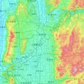
Name: Nara topographic map, elevation, terrain.

Location: Nara, Nara Prefecture, Japan (34.55805 135.71313 34.75774 136.07108)

Average elevation: 195 m

Minimum elevation: 1 m

Maximum elevation: 784 m

Other topographic maps

Click on a map to view its topography, its elevation and its terrain.

Mt. Suribachi

Japan > Furubira County > Furubira

Average elevation: 151 m

Akaishi Mountains

Japan > Shimoina District > Oshika

Average elevation: 2,591 m

Gear up for your next adventure:

🧢Beanie Hat - Keep your head warm in cold weather
🚲MTB Frame Bag - Carry tools and maps directly on your bicycle frame
🏕️Camping Hammock - Integrated protection for sleeping between trees
🛏️Sleeping Bag - Warm and compact sleeping bags for outdoor camping
🥾Light Trekking Boots - Supportive boots for multi-day treks

As an Amazon Associate, this site earns from qualifying purchases at no extra cost to you.