Geolocate

Wurzen topographic map

Click on the map to display elevation.

About this map

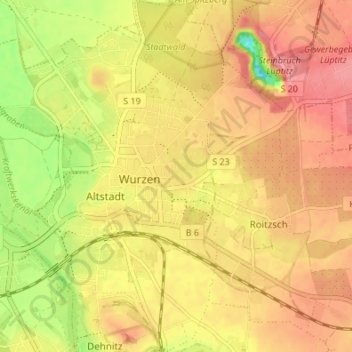
Name: Wurzen topographic map, elevation, terrain.

Location: Wurzen, Landkreis Leipzig, Saxony, Germany (51.35014 12.71103 51.39254 12.77835)

Average elevation: 128 m

Minimum elevation: 77 m

Maximum elevation: 159 m

Gear up for your next adventure:

👟Leg Gaiters - Keep debris, mud, and snow out of your boots
🪜Heavy Duty Carabiners - Multi-use clips for securing gear to your backpack
🧭GPS Tracker - Track your location in remote areas safely
Backpacking Tent - Lightweight tent for long-distance hiking trips
🔭Outdoor Binoculars - Lightweight binoculars for birdwatching and hiking

As an Amazon Associate, this site earns from qualifying purchases at no extra cost to you.