
Make a donation
Gear up for your next adventure:
As an Amazon Associate, this site earns from qualifying purchases at no extra cost to you.
Djebel Chélia topographic map
Click on the map to display elevation.
Make a donation
Gear up for your next adventure:
As an Amazon Associate, this site earns from qualifying purchases at no extra cost to you.
Djebel Chélia
Le djebel Chélia est une montagne située dans l'Est de l'Algérie. Il constitue le plus haut sommet de la chaîne montagneuse de l'Aurès, à la limite de la wilaya de Batna et de la wilaya de Khenchela. Il culmine à 2 328 mètres d'altitude. Le mont Chélia est le deuxième plus haut sommet d'Algérie après le mont Tahat dans le Hoggar et le plus haut régulièrement couvert de neige.
Make a donation
Gear up for your next adventure:
As an Amazon Associate, this site earns from qualifying purchases at no extra cost to you.
About this map
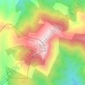
Name: Djebel Chélia topographic map, elevation, terrain.
Location: Djebel Chélia, Yabous, Daïra Bouhmama, Khenchela, Algérie (35.31837 6.63669 35.31847 6.63679)
Average elevation: 1,990 m
Minimum elevation: 1,638 m
Maximum elevation: 2,316 m
Make a donation
Gear up for your next adventure:
As an Amazon Associate, this site earns from qualifying purchases at no extra cost to you.