Geolocate

Paca topographic map

Click on the map to display elevation.

About this map

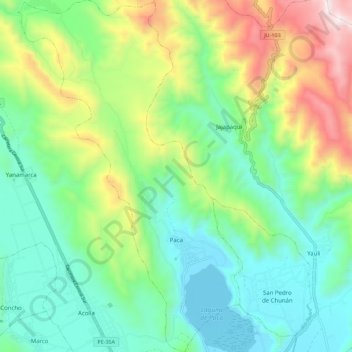
Name: Paca topographic map, elevation, terrain.

Location: Paca, Province of Jauja, Junín, Peru (-11.74351 -75.56817 -11.63462 -75.49710)

Average elevation: 3,708 m

Minimum elevation: 3,357 m

Maximum elevation: 4,498 m

Other topographic maps

Click on a map to view its topography, its elevation and its terrain.

Cañete

Peru > Junín > Mazamari

Average elevation: 737 m

Gear up for your next adventure:

🎒Hiking Backpack - Lightweight and ergonomic backpacks for day hikes or multi-day treks
🚲Heavy Duty Bike Lock - Secure your bike at the trailhead or during stops
👟Leg Gaiters - Keep debris, mud, and snow out of your boots
🥾Mountain Hiking Shoes - Shoes with superior grip for mountainous terrain
🥾Hiking Shorts - Breathable shorts suitable for summer hikes

As an Amazon Associate, this site earns from qualifying purchases at no extra cost to you.