Geolocate

Mount Olympus topographic map

Click on the map to display elevation.

About this map

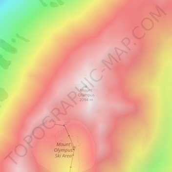
Name: Mount Olympus topographic map, elevation, terrain.

Location: Mount Olympus, Selwyn District, New Zealand (-43.18346 171.61004 -43.18336 171.61014)

Average elevation: 1,631 m

Minimum elevation: 697 m

Maximum elevation: 2,077 m

Other topographic maps

Click on a map to view its topography, its elevation and its terrain.

Torlesse Range

New Zealand > Selwyn District

Average elevation: 1,059 m

Big Ben Range

New Zealand > Selwyn District

Average elevation: 1,190 m

Craigieburn Range

New Zealand > Selwyn District

Average elevation: 1,168 m

Polar Range

New Zealand > Selwyn District

Average elevation: 1,454 m

Lake Minchin

New Zealand > Selwyn District

Average elevation: 1,092 m

Cascade Range

New Zealand > Selwyn District

Average elevation: 1,266 m

Cascade Range

New Zealand > Selwyn District

Average elevation: 1,266 m

Lake Pearson

New Zealand > Selwyn District

Average elevation: 822 m

Gear up for your next adventure:

💡LED Headlamp - Hands-free illumination for night hiking and camping
🩹Moleskin Blister Pads - Direct protection for painful foot pressure points
🔪Outdoor Multitool - Versatile tool for repairs and food prep in the wild
🥾Mountain Hiking Boots - High-traction boots for rocky terrain
🥾Hiking Shorts - Breathable shorts suitable for summer hikes

As an Amazon Associate, this site earns from qualifying purchases at no extra cost to you.