
Thank you for supporting this site ❤️
Make a donation
Make a donation
Gear up for your next adventure:
As an Amazon Associate, this site earns from qualifying purchases at no extra cost to you.
Estremoz topographic map
Click on the map to display elevation.
Thank you for supporting this site ❤️
Make a donation
Make a donation
Gear up for your next adventure:
As an Amazon Associate, this site earns from qualifying purchases at no extra cost to you.
About this map
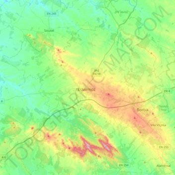
Name: Estremoz topographic map, elevation, terrain.
Location: Estremoz, Évora, Portugal (38.68486 -7.79995 39.00844 -7.45271)
Average elevation: 308 m
Minimum elevation: 178 m
Maximum elevation: 651 m
Thank you for supporting this site ❤️
Make a donation
Make a donation
Gear up for your next adventure:
As an Amazon Associate, this site earns from qualifying purchases at no extra cost to you.
Other topographic maps
Click on a map to view its topography, its elevation and its terrain.
Montemor
Portugal > Évora > Nossa Senhora da Vila, Nossa Senhora do Bispo e Silveiras
Average elevation: 222 m