Geolocate

Pedrezuela topographic map

Click on the map to display elevation.

About this map

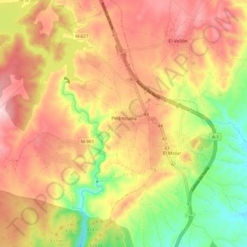
Name: Pedrezuela topographic map, elevation, terrain.

Location: Pedrezuela, Community of Madrid, 28723, Spain (40.70710 -3.67708 40.77965 -3.59180)

Average elevation: 830 m

Minimum elevation: 673 m

Maximum elevation: 959 m

Other topographic maps

Click on a map to view its topography, its elevation and its terrain.

Madrid

Spain > Community of Madrid > Madrid

Average elevation: 650 m

Fuente Pila

Spain > Community of Madrid > Navalcarnero

Average elevation: 631 m

Eurovillas

Spain > Community of Madrid > Eurovillas

Average elevation: 826 m

Montecillo

Spain > Community of Madrid > Las Vegas > Villaconejos

Average elevation: 677 m

Gear up for your next adventure:

🥾Approach Shoes - Shoes designed for climbing approaches and rugged trails
Tent Footprint - Protect tent floor and increase durability
🏃Hydration Running Vest - Carry water and maps close to your body for speed
🚲Bike Repair Kit - Essential tools for on-trail mechanical issues
🧥Waterproof Jacket - Lightweight rain jackets for hiking and outdoor activities

As an Amazon Associate, this site earns from qualifying purchases at no extra cost to you.