Geolocate

Tomatlán topographic map

Click on the map to display elevation.

About this map

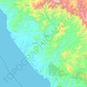
Name: Tomatlán topographic map, elevation, terrain.

Location: Tomatlán, Jalisco, Mexico (19.64254 -105.54956 20.23276 -104.62031)

Average elevation: 385 m

Minimum elevation: -3 m

Maximum elevation: 2,687 m

Gear up for your next adventure:

🔦LED Headlamp - Hands-free lighting for early morning starts or late finishes
🧥Thermal Fleece Jacket - Versatile insulation for changing mountain temperatures
🥾Approach Boots - Comfortable boots for hiking and climbing approaches
🦶Anti-Blister Balm - Prevents friction and hotspots during long ascents
🦶Hiking Shoe Insoles - Added support for high arches and long days on feet

As an Amazon Associate, this site earns from qualifying purchases at no extra cost to you.