Geolocate

Luena topographic map

Click on the map to display elevation.

About this map

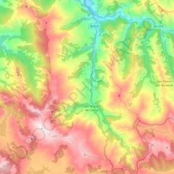
Name: Luena topographic map, elevation, terrain.

Location: Luena, Cantabria, Spain (43.03909 -3.96075 43.18467 -3.83177)

Average elevation: 739 m

Minimum elevation: 184 m

Maximum elevation: 1,321 m

Other topographic maps

Click on a map to view its topography, its elevation and its terrain.

Quintanamanil

Spain > Cantabria > Campoo de Yuso > La Costana

Average elevation: 868 m

Cueto

Spain > Cantabria > Santander

Average elevation: 20 m

Gear up for your next adventure:

🔥Emergency Fire Starter - Reliable ignition source for all weather conditions
🔭Compact Monocular - One-handed bird watching and trail spotting
🧦Merino Wool Socks - Moisture-wicking comfort for long-distance hiking
🧢Outdoor Visor - Breathable visor for sunny hikes
🧤Thermal Hiking Gloves - Grip-enhanced gloves for cold-weather altitude trekking

As an Amazon Associate, this site earns from qualifying purchases at no extra cost to you.