Geolocate

Laon topographic map

Click on the map to display elevation.

About this map

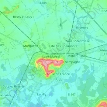
Name: Laon topographic map, elevation, terrain.

Location: Laon, Aisne, Hauts-de-France, Metropolitan France, 02000, France (49.52857 3.55569 49.61379 3.66983)

Average elevation: 78 m

Minimum elevation: 59 m

Maximum elevation: 191 m

Other topographic maps

Click on a map to view its topography, its elevation and its terrain.

Montcourt

France > Hauts-de-France > Aisne > Essômes-sur-Marne

Average elevation: 133 m

Buirefontaine

France > Hauts-de-France > Aisne > Aubenton

Average elevation: 198 m

Coutenval

France > Hauts-de-France > Aisne > Jeantes

Average elevation: 201 m

Les Hausseaux

France > Hauts-de-France > Aisne > Any-Martin-Rieux

Average elevation: 214 m

La Rue Charles

France > Hauts-de-France > Aisne > Besmont

Average elevation: 204 m

Le Bac

France > Hauts-de-France > Aisne > Bichancourt

Average elevation: 49 m

Reddy

France > Hauts-de-France > Aisne > Coulonges-Cohan

Average elevation: 190 m

Gear up for your next adventure:

🥘Camping Cookware Set - Compact nesting pots and pans for trail cooking
💧Collapsible Water Bottle - Space-saving water bottle for outdoor activities
🥾Hiking Boots - Sturdy boots providing ankle support and traction on rugged trails
🧥Softshell Jacket - Windproof and breathable jacket for hiking
🥫Freeze-Dried Meals - Lightweight, high-calorie nutrition for multi-day treks

As an Amazon Associate, this site earns from qualifying purchases at no extra cost to you.