
Make a donation
Gear up for your next adventure:
As an Amazon Associate, this site earns from qualifying purchases at no extra cost to you.
Matour topographic map
Click on the map to display elevation.
Make a donation
Gear up for your next adventure:
As an Amazon Associate, this site earns from qualifying purchases at no extra cost to you.
Matour
Matour is a village with a medium and low altitude. The highest point is located to the north-west in the mountain range of the Mont Saint-Cyr and reaches 769 meters of altitude, the lowest point being 328 meters. Very rugged, the village is dominated by multiple rounded mountains and capped with forests as.
Make a donation
Gear up for your next adventure:
As an Amazon Associate, this site earns from qualifying purchases at no extra cost to you.
About this map
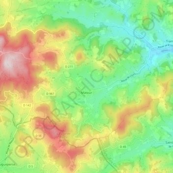
Name: Matour topographic map, elevation, terrain.
Average elevation: 491 m
Minimum elevation: 308 m
Maximum elevation: 761 m
Make a donation
Gear up for your next adventure:
As an Amazon Associate, this site earns from qualifying purchases at no extra cost to you.
Other topographic maps
Click on a map to view its topography, its elevation and its terrain.
La Pommeraye
France > Bourgogne-Franche-Comté > Saône-et-Loire > Beaurepaire-en-Bresse
Average elevation: 210 m
Make a donation
Gear up for your next adventure:
As an Amazon Associate, this site earns from qualifying purchases at no extra cost to you.
Les Coches
France > Bourgogne-Franche-Comté > Saône-et-Loire > Chenay-le-Châtel
Average elevation: 306 m