Geolocate

Rabenstein topographic map

Click on the map to display elevation.

About this map

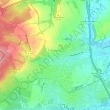
Name: Rabenstein topographic map, elevation, terrain.

Location: Rabenstein, Chemnitz, Saxony, 09117, Germany (50.81822 12.80946 50.84866 12.85065)

Average elevation: 348 m

Minimum elevation: 307 m

Maximum elevation: 418 m

Gear up for your next adventure:

🎒Fully Waterproof Backpack - Total protection for photography gear and electronics
Camping Groundsheet - Protect your tent from moisture and dirt
🕶️Polarized Sunglasses - Protect your eyes with durable polarized lenses
🥾Light Hiking Boots - Lightweight and comfortable boots for day hikes
🧢Sun Protection Cap - Breathable cap to protect from sun exposure

As an Amazon Associate, this site earns from qualifying purchases at no extra cost to you.