
Make a donation
Gear up for your next adventure:
As an Amazon Associate, this site earns from qualifying purchases at no extra cost to you.
Cuautla topographic map
Click on the map to display elevation.
Make a donation
Gear up for your next adventure:
As an Amazon Associate, this site earns from qualifying purchases at no extra cost to you.
Cuautla
Cuautla is located in the eastern Morelos, with the geographic coordinates 18°49'N and 99°01'E and an altitude of 1,294 meters (4,245 feet) above sea level. Cuautla borders the municipalities of Atlatlahucan, Ayala, Yautepec, and Yecapixtla.
Make a donation
Gear up for your next adventure:
As an Amazon Associate, this site earns from qualifying purchases at no extra cost to you.
About this map
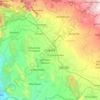
Name: Cuautla topographic map, elevation, terrain.
Location: Cuautla, Morelos, 62740, Mexico (18.66901 -99.10322 18.98901 -98.78322)
Average elevation: 1,435 m
Minimum elevation: 936 m
Maximum elevation: 2,357 m
Make a donation
Gear up for your next adventure:
As an Amazon Associate, this site earns from qualifying purchases at no extra cost to you.