

Make a donation
Gear up for your next adventure:
As an Amazon Associate, this site earns from qualifying purchases at no extra cost to you.
La Crosse topographic map
Click on the map to display elevation.
Make a donation
Gear up for your next adventure:
As an Amazon Associate, this site earns from qualifying purchases at no extra cost to you.
La Crosse
Surrounding the relatively flat prairie valley where La Crosse lies are towering 500-foot (150 m) bluffs, one of the most prominent of which is Grandad Bluff (mentioned in Life on the Mississippi by Mark Twain), which has an overlook of the three states region. This feature typifies the topography of the Driftless Area in which La Crosse sits. This rugged region is composed of high ridges dissected by narrow valleys called coulees, a French term. As a result, the area around La Crosse is frequently referred to as the "Coulee Region".
Make a donation
Gear up for your next adventure:
As an Amazon Associate, this site earns from qualifying purchases at no extra cost to you.
About this map
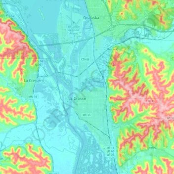
Name: La Crosse topographic map, elevation, terrain.
Location: La Crosse, La Crosse County, Wisconsin, United States (43.74602 -91.27594 43.89838 -91.15709)
Average elevation: 238 m
Minimum elevation: 188 m
Maximum elevation: 391 m
Make a donation
Gear up for your next adventure:
As an Amazon Associate, this site earns from qualifying purchases at no extra cost to you.
Other topographic maps
Click on a map to view its topography, its elevation and its terrain.
Make a donation
Gear up for your next adventure:
As an Amazon Associate, this site earns from qualifying purchases at no extra cost to you.
Village of West Salem
United States > Wisconsin > La Crosse County > West Salem
Average elevation: 226 m