Geolocate

Metropolitan France topographic map

Click on the map to display elevation.

About this map

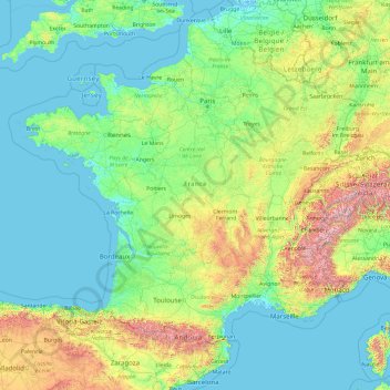
Name: Metropolitan France topographic map, elevation, terrain.

Location: Metropolitan France, France (41.26322 -5.45343 51.26832 9.86783)

Average elevation: 301 m

Minimum elevation: -3 m

Maximum elevation: 4,188 m

Gear up for your next adventure:

🚲Bike Repair Kit - Essential tools for on-trail mechanical issues
🪑Ultralight Camping Stool - Compact seating for rest stops during long hikes
🧶550 Survival Paracord - Versatile utility cord for emergency repairs and rigging
Camping Groundsheet - Protect your tent from moisture and dirt
🧦Hiking Liner Socks - Thin base layer to prevent friction and blisters

As an Amazon Associate, this site earns from qualifying purchases at no extra cost to you.