Geolocate

Manta topographic map

Click on the map to display elevation.

About this map

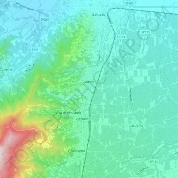
Name: Manta topographic map, elevation, terrain.

Location: Manta, Cuneo, Piemont, Italy (44.60186 7.45223 44.62493 7.55698)

Average elevation: 439 m

Minimum elevation: 298 m

Maximum elevation: 1,049 m

Gear up for your next adventure:

🌬️Windproof Camp Stove - Efficient cooking even on exposed mountain peaks
🔋Lithium AA Batteries - Long-lasting power that performs in extreme cold
🥾Hiking Shoes - Durable and comfortable shoes for trail hiking
🥾Hiking Boots - Sturdy boots providing ankle support and traction on rugged trails
🧢Outdoor Visor - Breathable visor for sunny hikes

As an Amazon Associate, this site earns from qualifying purchases at no extra cost to you.