Geolocate

Chawla Colony topographic map

Click on the map to display elevation.

About this map

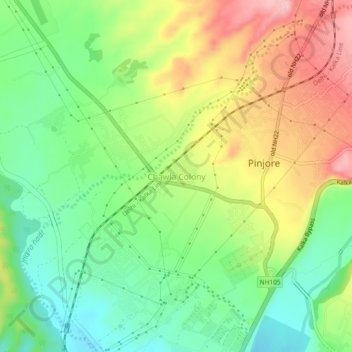
Name: Chawla Colony topographic map, elevation, terrain.

Location: Chawla Colony, Kalka, Panchkula, Haryana, 134102, India (30.78260 76.88337 30.82260 76.92337)

Average elevation: 529 m

Minimum elevation: 464 m

Maximum elevation: 616 m

Gear up for your next adventure:

🧢Beanie Hat - Keep your head warm in cold weather
🧭GPS Outdoor Watch - Smart watch for navigation and fitness tracking in nature
Bushcraft Tarp - Versatile emergency shelter or gear protection
💧Reusable Water Bottle - Durable water bottles for hydration on trails
🥾Approach Shoes - Shoes designed for climbing approaches and rugged trails

As an Amazon Associate, this site earns from qualifying purchases at no extra cost to you.