
Thank you for supporting this site ❤️
Make a donation
Make a donation
Gear up for your next adventure:
As an Amazon Associate, this site earns from qualifying purchases at no extra cost to you.
Ursi topographic map
Click on the map to display elevation.
Thank you for supporting this site ❤️
Make a donation
Make a donation
Gear up for your next adventure:
As an Amazon Associate, this site earns from qualifying purchases at no extra cost to you.
About this map
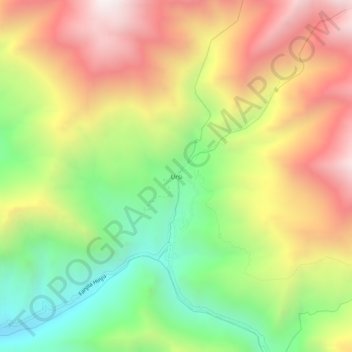
Name: Ursi topographic map, elevation, terrain.
Location: Ursi, Khalsi tehsil, Leh District, Ladakh, India (34.19643 76.87440 34.23643 76.91440)
Average elevation: 3,941 m
Minimum elevation: 3,290 m
Maximum elevation: 4,639 m
Thank you for supporting this site ❤️
Make a donation
Make a donation
Gear up for your next adventure:
As an Amazon Associate, this site earns from qualifying purchases at no extra cost to you.