
Make a donation
Gear up for your next adventure:
As an Amazon Associate, this site earns from qualifying purchases at no extra cost to you.
Rotorua topographic map
Click on the map to display elevation.
Make a donation
Gear up for your next adventure:
As an Amazon Associate, this site earns from qualifying purchases at no extra cost to you.
About this map
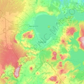
Name: Rotorua topographic map, elevation, terrain.
Average elevation: 435 m
Minimum elevation: 215 m
Maximum elevation: 860 m
Make a donation
Gear up for your next adventure:
As an Amazon Associate, this site earns from qualifying purchases at no extra cost to you.
Other topographic maps
Click on a map to view its topography, its elevation and its terrain.
Lake Ōkareka
New Zealand > Bay of Plenty > Rotorua Lakes District > Lake Okareka
Average elevation: 392 m
Lake Rotomā
New Zealand > Bay of Plenty > Rotorua Lakes District > Lake Rotomā
Average elevation: 357 m
Make a donation
Gear up for your next adventure:
As an Amazon Associate, this site earns from qualifying purchases at no extra cost to you.
Lake Ōkataina / Te Moana i kataina ā Te Rangitakaroro
New Zealand > Bay of Plenty > Rotorua Lakes District
Average elevation: 440 m
Tikitapu / Blue Lake
New Zealand > Bay of Plenty > Rotorua Lakes District > Rotorua
Average elevation: 520 m
Lake Rotokakahi (Green Lake) Scenic Reserve
New Zealand > Bay of Plenty > Rotorua Lakes District > Rotorua
Average elevation: 483 m
Make a donation
Gear up for your next adventure:
As an Amazon Associate, this site earns from qualifying purchases at no extra cost to you.
Lake Ōkareka
New Zealand > Bay of Plenty > Rotorua Lakes District > Lake Okareka
Average elevation: 392 m
Lake Ōkareka
New Zealand > Bay of Plenty > Rotorua Lakes District > Lake Okareka
Average elevation: 392 m
Make a donation
Gear up for your next adventure:
As an Amazon Associate, this site earns from qualifying purchases at no extra cost to you.