
Make a donation
Gear up for your next adventure:
As an Amazon Associate, this site earns from qualifying purchases at no extra cost to you.
Ashland topographic map
Click on the map to display elevation.
Make a donation
Gear up for your next adventure:
As an Amazon Associate, this site earns from qualifying purchases at no extra cost to you.
About this map
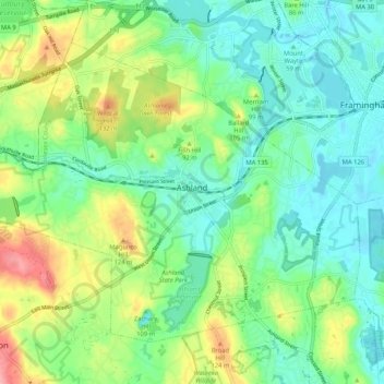
Name: Ashland topographic map, elevation, terrain.
Average elevation: 81 m
Minimum elevation: 45 m
Maximum elevation: 158 m
Make a donation
Gear up for your next adventure:
As an Amazon Associate, this site earns from qualifying purchases at no extra cost to you.
Other topographic maps
Click on a map to view its topography, its elevation and its terrain.
South Chelmsford
United States > Massachusetts > Middlesex County > Chelmsford
Average elevation: 65 m
Make a donation
Gear up for your next adventure:
As an Amazon Associate, this site earns from qualifying purchases at no extra cost to you.
South Sudbury
United States > Massachusetts > Middlesex County > Sudbury > South Sudbury
Average elevation: 53 m
North Reading
United States > Massachusetts > Middlesex County > North Reading
Average elevation: 33 m
Make a donation
Gear up for your next adventure:
As an Amazon Associate, this site earns from qualifying purchases at no extra cost to you.
Haywardville
United States > Massachusetts > Middlesex County > Stoneham > Haywardville
Average elevation: 46 m