Geolocate

Calella topographic map

Click on the map to display elevation.

About this map

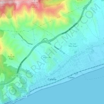
Name: Calella topographic map, elevation, terrain.

Location: Calella, Maresme, Barcelona, Catalonia, 08370, Spain (41.60473 2.62778 41.64071 2.67168)

Average elevation: 82 m

Minimum elevation: 0 m

Maximum elevation: 405 m

Other topographic maps

Click on a map to view its topography, its elevation and its terrain.

el Masnou

Spain > Catalonia > Maresme > el Masnou > el Masnou

Average elevation: 92 m

Palafolls

Spain > Catalonia > Maresme > Palafolls > Palafolls

Average elevation: 26 m

Gear up for your next adventure:

🔭Compact Monocular - One-handed bird watching and trail spotting
🔋Solar Power Bank - Keep your GPS and devices charged during long outdoor trips
🔭Compact Binoculars - Lightweight optics for scouting trails and wildlife
🚲MTB Frame Bag - Carry tools and maps directly on your bicycle frame
🎒Hiking Backpack - Lightweight and ergonomic backpacks for day hikes or multi-day treks

As an Amazon Associate, this site earns from qualifying purchases at no extra cost to you.