Geolocate

Aguascalientes topographic map

Click on the map to display elevation.

Aguascalientes

The Aguascalientes Bicentenary Velodrome, designed by Peter Junek, hosted the 2010 Pan American Track Championships. At an Elevation of 1887m, the Velodrome is a frequent location for attempts at breaking the Cycling Hour Record

Wikipedia (CC-BY-SA 3.0)

About this map

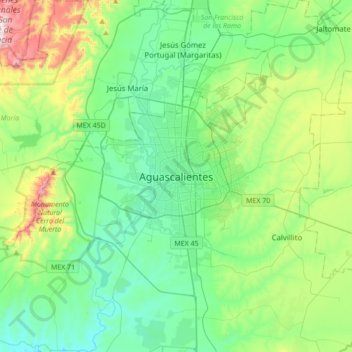
Name: Aguascalientes topographic map, elevation, terrain.

Location: Aguascalientes, Municipio de Aguascalientes, Aguascalientes, 20000, Mexico (21.72049 -102.45672 22.04049 -102.13672)

Average elevation: 1,956 m

Minimum elevation: 1,777 m

Maximum elevation: 2,514 m

Gear up for your next adventure:

💡Solar Camping Lamp - Eco-friendly lighting for campsites
🐕Hiking Dog Pack - Let your canine companion carry their own water and food
Camping Groundsheet - Protect your tent from moisture and dirt
🦟Insect Repellent - Keep mosquitoes and black flies away in wooded areas
🥘Camping Cookware Set - Compact nesting pots and pans for trail cooking

As an Amazon Associate, this site earns from qualifying purchases at no extra cost to you.