Geolocate

Guevarra topographic map

Click on the map to display elevation.

About this map

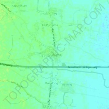
Name: Guevarra topographic map, elevation, terrain.

Location: Guevarra, La Paz, Tarlac, Central Luzon, 2314, Philippines (15.45725 120.69791 15.49725 120.73791)

Average elevation: 20 m

Minimum elevation: 15 m

Maximum elevation: 25 m

Other topographic maps

Click on a map to view its topography, its elevation and its terrain.

Rio Chico

Philippines > Tarlac > La Paz

Average elevation: 15 m

Gear up for your next adventure:

🧦Merino Wool Socks - Moisture-wicking comfort for long-distance hiking
🧰Emergency Multi-Tool - Compact multi-tool for outdoor survival
👟Sport Hiking Sandals - Breathable footwear for water crossings and camp rest
💧Collapsible Water Bottle - Space-saving water bottle for outdoor activities
Camping Groundsheet - Protect your tent from moisture and dirt

As an Amazon Associate, this site earns from qualifying purchases at no extra cost to you.