
Inverness topographic map
Interactive map
Click on the map to display elevation.
About this map
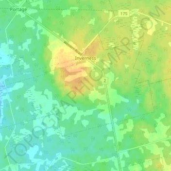
Name: Inverness topographic map, elevation, terrain.
Average elevation: 12 m
Minimum elevation: -1 m
Maximum elevation: 28 m
Other topographic maps
Click on a map to view its topography, its elevation and its terrain.
Ellerslie-Bideford
Canada > Prince Edward Island > Rural Municipality of Central Prince
Ellerslie-Bideford, Rural Municipality of Central Prince, Prince County, Prince Edward Island, C0B 1J0, Canada
Average elevation: 17 m
Mount Pleasant
Canada > Prince Edward Island > Rural Municipality of Central Prince
Mount Pleasant, Rural Municipality of Central Prince, Prince County, Prince Edward Island, Canada
Average elevation: 23 m