Geolocate

Tanauan topographic map

Click on the map to display elevation.

About this map

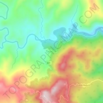
Name: Tanauan topographic map, elevation, terrain.

Location: Tanauan, Real, Quezon, Calabarzon, Philippines (14.53677 121.57293 14.57677 121.61293)

Average elevation: 202 m

Minimum elevation: 14 m

Maximum elevation: 459 m

Gear up for your next adventure:

🥾Trail Running Shoes - Lightweight and durable shoes for trail running
💡LED Headlamp - Hands-free illumination for night hiking and camping
🏕️Camping Hammock - Integrated protection for sleeping between trees
🧥Thermal Layer - Insulating layer for cold outdoor conditions
🎒Fully Waterproof Backpack - Total protection for photography gear and electronics

As an Amazon Associate, this site earns from qualifying purchases at no extra cost to you.