Geolocate

Cortazzone topographic map

Click on the map to display elevation.

About this map

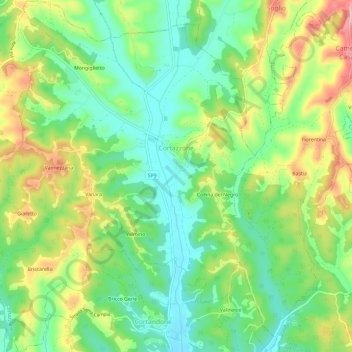
Name: Cortazzone topographic map, elevation, terrain.

Location: Cortazzone, Asti, Piedmont, Italy (44.95531 8.02780 44.99720 8.07491)

Average elevation: 226 m

Minimum elevation: 171 m

Maximum elevation: 310 m

Other topographic maps

Click on a map to view its topography, its elevation and its terrain.

Zolfo

Italy > Piedmont > Asti > Montafia

Average elevation: 226 m

Gear up for your next adventure:

🧢Hiking Sun Hat - Wide-brimmed protection for exposed mountain ridges
🦶Anti-Blister Balm - Prevents friction and hotspots during long ascents
🥾Mountaineering Boots - Supportive boots for climbing and high-altitude hiking
🔨Vehicle Emergency Tool - Safety tool for remote road trips to trailheads
🎒Fully Waterproof Backpack - Total protection for photography gear and electronics

As an Amazon Associate, this site earns from qualifying purchases at no extra cost to you.