Geolocate

Taufkirchen topographic map

Click on the map to display elevation.

About this map

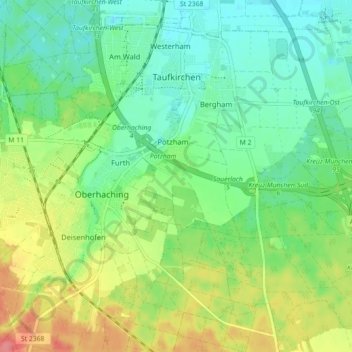
Name: Taufkirchen topographic map, elevation, terrain.

Location: Taufkirchen, Landkreis München, Bavaria, 82024, Germany (48.00307 11.58469 48.05521 11.67378)

Average elevation: 580 m

Minimum elevation: 554 m

Maximum elevation: 628 m

Other topographic maps

Click on a map to view its topography, its elevation and its terrain.

Martinsried

Germany > Bavaria > Landkreis München > Planegg

Average elevation: 549 m

Hofolding

Germany > Bavaria > Landkreis München

Average elevation: 609 m

Holzhausen

Germany > Bavaria > Landkreis München

Average elevation: 663 m

Eglfing

Germany > Bavaria > Landkreis München > Haar

Average elevation: 540 m

Deisenhofen

Germany > Bavaria > Landkreis München > Oberhaching

Average elevation: 592 m

Westerham

Germany > Bavaria > Landkreis München > Taufkirchen > Westerham

Average elevation: 565 m

Gear up for your next adventure:

💧Filtered Water Bottle - Safe drinking water on the go
🧭GPS Handheld Device - Reliable GPS navigation for outdoor adventures
🧊Insulated Water Bottle - Keeps drinks cold in summer and prevents freezing in winter
🥾Lightweight Hiking Boots - Boots for comfort and mobility on long hikes
🧦Hiking Socks - Moisture-wicking and comfortable socks for long hikes

As an Amazon Associate, this site earns from qualifying purchases at no extra cost to you.