Geolocate

Barre topographic map

Click on the map to display elevation.

About this map

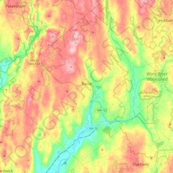
Name: Barre topographic map, elevation, terrain.

Location: Barre, Worcester County, Massachusetts, United States (42.35642 -72.20515 42.48452 -72.00739)

Average elevation: 278 m

Minimum elevation: 170 m

Maximum elevation: 382 m

Other topographic maps

Click on a map to view its topography, its elevation and its terrain.

Gear up for your next adventure:

🧦Hiking Socks - Moisture-wicking and comfortable socks for long hikes
🧢Hiking Hat - Sun-protective and breathable hats for long treks
🛰️Satellite Messenger - Emergency communication for areas with no cell service
🥾Waterproof Hiking Boots - Essential footwear for rugged terrain and wet Canadian trails
🥾Mountain Hiking Shoes - Shoes with superior grip for mountainous terrain

As an Amazon Associate, this site earns from qualifying purchases at no extra cost to you.