Geolocate

Hexham topographic map

Click on the map to display elevation.

About this map

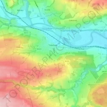
Name: Hexham topographic map, elevation, terrain.

Location: Hexham, Northumberland, England, United Kingdom (54.94376 -2.17847 54.98884 -2.06311)

Average elevation: 122 m

Minimum elevation: 24 m

Maximum elevation: 272 m

Other topographic maps

Click on a map to view its topography, its elevation and its terrain.

Gains Law

United Kingdom > England > Northumberland

Average elevation: 229 m

Woeful Hill

United Kingdom > England > Northumberland

Average elevation: 137 m

Low Espley

United Kingdom > England > Northumberland > Hebron

Average elevation: 105 m

Cowpen

United Kingdom > England > Northumberland > Blyth

Average elevation: 15 m

Gear up for your next adventure:

🧦Crew Hiking Socks - Comfortable socks for long-distance hikes
🧳Compression Sacks - Maximize space in your backpack by shrinking gear
🥾Hiking Leggings - Comfortable leggings for outdoor activities
🕯️Camping Lantern - Illuminates your entire campsite with high-efficiency LEDs
🥾Hiking Boots - Sturdy boots providing ankle support and traction on rugged trails

As an Amazon Associate, this site earns from qualifying purchases at no extra cost to you.