
Sand Point topographic map
Click on the map to display elevation.
About this map
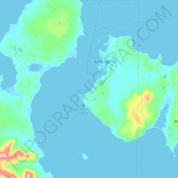
Name: Sand Point topographic map, elevation, terrain.
Location: Sand Point, Aleutians East Borough, Alaska, United States (55.26667 -160.58043 55.38337 -160.45833)
Average elevation: 39 m
Minimum elevation: -6 m
Maximum elevation: 493 m
Other topographic maps
Click on a map to view its topography, its elevation and its terrain.
Shishaldin Volcano
United States > Alaska > Aleutians East Borough
Shishaldin is located on Unimak Island, the easternmost of the Aleutian Islands. The nearest settlement to the volcano is False Pass (population ~100) at 45 km away. The view of Shishaldin from False Pass is obscured by the Round Top and Isanotski volcanoes, preventing direct observations of eruptions in many…
Average elevation: 2,134 m