Geolocate

Curtis topographic map

Click on the map to display elevation.

About this map
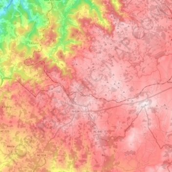
Name: Curtis topographic map, elevation, terrain.

Location: Curtis, Betanzos, A Coruña, Galicia, Spain (43.08422 -8.15978 43.18653 -7.94289)

Average elevation: 503 m

Minimum elevation: 170 m

Maximum elevation: 746 m

Other topographic maps

Click on a map to view its topography, its elevation and its terrain.
Montelongo

Spain > Galicia > Betanzos > Oza

Average elevation: 193 m

Tiúlfe

Spain > Galicia > Betanzos

Average elevation: 283 m

Cendá

Spain > Galicia > Betanzos

Average elevation: 249 m

Cesuras

Spain > Galicia > Betanzos

Average elevation: 318 m

Burricios

Spain > Galicia > Betanzos > Oza-Cesuras

Average elevation: 267 m

Quistilan

Spain > Galicia > Betanzos

Average elevation: 169 m

Ansimonde

Spain > Galicia > Betanzos > Miño

Average elevation: 150 m

As Brañas

Spain > Galicia > Betanzos > O Pazo de Irixoa

Average elevation: 379 m

Gear up for your next adventure:

🥾Waterproof Hiking Shoes - Durable shoes for wet and rugged trails
🥾All-Terrain Hiking Boots - Versatile boots for varied hiking conditions
🦶Anti-Blister Balm - Prevents friction and hotspots during long ascents
🔦LED Headlamp - Hands-free lighting for early morning starts or late finishes
🧦Hiking Liner Socks - Thin base layer to prevent friction and blisters

As an Amazon Associate, this site earns from qualifying purchases at no extra cost to you.