
Make a donation
Gear up for your next adventure:
As an Amazon Associate, this site earns from qualifying purchases at no extra cost to you.
Guadalajara topographic map
Click on the map to display elevation.
Make a donation
Gear up for your next adventure:
As an Amazon Associate, this site earns from qualifying purchases at no extra cost to you.
Guadalajara
Under the Köppen climate classification, Guadalajara has a humid subtropical climate (Cwa) that is quite close to a tropical climate, featuring dry, warm winters and hot, wet summers. Guadalajara's climate is influenced by its high altitude and the general seasonality of precipitation patterns in western North America.
Make a donation
Gear up for your next adventure:
As an Amazon Associate, this site earns from qualifying purchases at no extra cost to you.
About this map
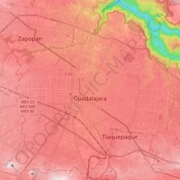
Name: Guadalajara topographic map, elevation, terrain.
Location: Guadalajara, Región Centro, Jalisco, Mexico (20.60374 -103.40706 20.75270 -103.26376)
Average elevation: 1,543 m
Minimum elevation: 981 m
Maximum elevation: 1,776 m
Make a donation
Gear up for your next adventure:
As an Amazon Associate, this site earns from qualifying purchases at no extra cost to you.
Other topographic maps
Click on a map to view its topography, its elevation and its terrain.
Make a donation
Gear up for your next adventure:
As an Amazon Associate, this site earns from qualifying purchases at no extra cost to you.