
Thank you for supporting this site ❤️
Make a donation
Make a donation
Gear up for your next adventure:
As an Amazon Associate, this site earns from qualifying purchases at no extra cost to you.
Molina topographic map
Click on the map to display elevation.
Thank you for supporting this site ❤️
Make a donation
Make a donation
Gear up for your next adventure:
As an Amazon Associate, this site earns from qualifying purchases at no extra cost to you.
About this map
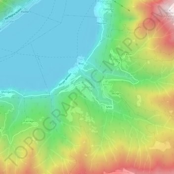
Name: Molina topographic map, elevation, terrain.
Location: Molina, Faggeto Lario, Como, Lombardy, 22020, Italy (45.83854 9.13288 45.87854 9.17288)
Average elevation: 583 m
Minimum elevation: 190 m
Maximum elevation: 1,376 m
Thank you for supporting this site ❤️
Make a donation
Make a donation
Gear up for your next adventure:
As an Amazon Associate, this site earns from qualifying purchases at no extra cost to you.