Geolocate

Velden topographic map

Click on the map to display elevation.

About this map

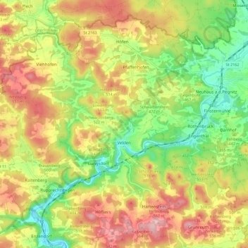
Name: Velden topographic map, elevation, terrain.

Location: Velden, Velden (VGem), Nürnberger Land, Bavaria, Germany (49.59281 11.42850 49.64480 11.53794)

Average elevation: 456 m

Minimum elevation: 361 m

Maximum elevation: 556 m

Other topographic maps

Click on a map to view its topography, its elevation and its terrain.

Stallbaum

Germany > Bavaria > Nürnberger Land > Hartmannshof

Average elevation: 478 m

Hartenberg

Germany > Bavaria > Nürnberger Land > Mosenhof

Average elevation: 519 m

Eschenbach

Germany > Bavaria > Nürnberger Land

Average elevation: 442 m

Houbirg

Germany > Bavaria > Nürnberger Land > Förrenbach

Average elevation: 435 m

Gear up for your next adventure:

🥾Light Hiking Boots - Lightweight and comfortable boots for day hikes
🥾Waterproof Trail Shoes - Shoes designed to handle wet terrain
Lightweight Camping Tent - Portable shelter optimized for Canadian backcountry camping
❄️Traction Ice Cleats - Slip-on spikes for icy trails and winter hiking
🧥Waterproof Hiking Jacket - Protect yourself from rain and wind while hiking

As an Amazon Associate, this site earns from qualifying purchases at no extra cost to you.