
Make a donation
Gear up for your next adventure:
As an Amazon Associate, this site earns from qualifying purchases at no extra cost to you.
Yerres topographic map
Click on the map to display elevation.
Make a donation
Gear up for your next adventure:
As an Amazon Associate, this site earns from qualifying purchases at no extra cost to you.
Yerres
Yerres lies in the North-Eastern part of Essonne and bordering the Val-de-Marne département. The town extends on both sides of the valley through which flows the river Yerres. The highest point is the wooded Mont Griffon, which reaches an altitude of 116 m, while the lowest point is at only 30 m above sea level.
Make a donation
Gear up for your next adventure:
As an Amazon Associate, this site earns from qualifying purchases at no extra cost to you.
About this map
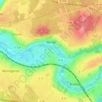
Name: Yerres topographic map, elevation, terrain.
Average elevation: 74 m
Minimum elevation: 31 m
Maximum elevation: 117 m
Make a donation
Gear up for your next adventure:
As an Amazon Associate, this site earns from qualifying purchases at no extra cost to you.