Geolocate

East Grinstead topographic map

Click on the map to display elevation.

About this map

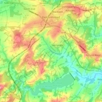
Name: East Grinstead topographic map, elevation, terrain.

Location: East Grinstead, West Sussex, England, United Kingdom (51.08623 -0.06037 51.14120 0.02779)

Average elevation: 104 m

Minimum elevation: 58 m

Maximum elevation: 156 m

Other topographic maps

Click on a map to view its topography, its elevation and its terrain.

Storrington

United Kingdom > England > West Sussex

Average elevation: 65 m

Bucks Green

United Kingdom > England > West Sussex > Horsham

Average elevation: 47 m

Nutbourne

United Kingdom > England > West Sussex > Chichester

Average elevation: 7 m

Felpham

United Kingdom > England > West Sussex > Arun

Average elevation: 2 m

Gear up for your next adventure:

🏕️Camping Hammock - Integrated protection for sleeping between trees
🕯️Camping Lantern - Illuminates your entire campsite with high-efficiency LEDs
💡Compact LED Flashlight - Powerful and portable flashlight for outdoor use
🧦Hiking Socks - Moisture-wicking and comfortable socks for long hikes
Lightweight Camping Tent - Portable shelter optimized for Canadian backcountry camping

As an Amazon Associate, this site earns from qualifying purchases at no extra cost to you.