
Make a donation
Gear up for your next adventure:
As an Amazon Associate, this site earns from qualifying purchases at no extra cost to you.
Arapiraca topographic map
Click on the map to display elevation.
Make a donation
Gear up for your next adventure:
As an Amazon Associate, this site earns from qualifying purchases at no extra cost to you.
Arapiraca
Its area is 351 square kilometers, located on a wide plain, at an altitude of 265 meters, 123 kilometers from Maceió and 44 kilometers from Palmeira dos Índios. The climate is considered one of the healthiest in the state.
Make a donation
Gear up for your next adventure:
As an Amazon Associate, this site earns from qualifying purchases at no extra cost to you.
About this map
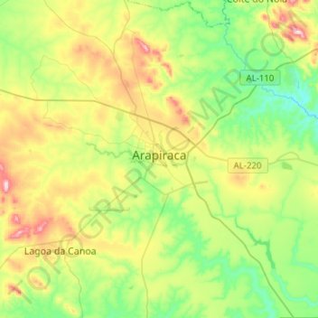
Name: Arapiraca topographic map, elevation, terrain.
Average elevation: 245 m
Minimum elevation: 130 m
Maximum elevation: 456 m
Make a donation
Gear up for your next adventure:
As an Amazon Associate, this site earns from qualifying purchases at no extra cost to you.
Other topographic maps
Click on a map to view its topography, its elevation and its terrain.