Geolocate

Bickerton topographic map

Click on the map to display elevation.

About this map

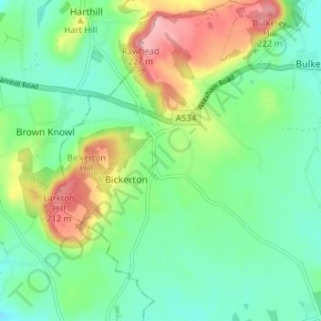
Name: Bickerton topographic map, elevation, terrain.

Location: Bickerton, Cheshire East, England, United Kingdom (53.05535 -2.75293 53.09353 -2.70949)

Average elevation: 128 m

Minimum elevation: 82 m

Maximum elevation: 222 m

Other topographic maps

Click on a map to view its topography, its elevation and its terrain.

Collins Wood

United Kingdom > England > Cheshire East

Average elevation: 91 m

Gear up for your next adventure:

🪑Insulated Seat Pad - Protect your seat from cold rocks and wet logs
🧦Hiking Socks - Moisture-wicking and comfortable socks for long hikes
🧦Thermal Socks - Warm socks for winter hiking or camping
🕯️Camping Lantern - Illuminates your entire campsite with high-efficiency LEDs
🧭GPS Handheld Device - Reliable GPS navigation for outdoor adventures

As an Amazon Associate, this site earns from qualifying purchases at no extra cost to you.