Aztec topographic map
Interactive map
Click on the map to display elevation.
About this map
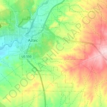
Name: Aztec topographic map, elevation, terrain.
Location: Aztec, San Juan County, New Mexico, United States (36.76484 -108.03648 36.85535 -107.91504)
Average elevation: 1,803 m
Minimum elevation: 1,692 m
Maximum elevation: 1,974 m
Yet another area managed by the BLM, this area was formed about the same time as the Bisti and Ah-Shi-Sle-Pah. This region offers a uniquely different scale of landscape. Hoodoo in this region are massive and the terrain much greater in elevation differences, thereby exposing a greater geological time frame than the Bisti or Ah-Shi-Sle-Pah. This region is a bit more accessible due to oil field roads traversing the region. However, extreme caution is required when driving on as these roads as they are impassible when wet.
Other topographic maps
Click on a map to view its topography, its elevation and its terrain.
Farmington
United States > New Mexico > San Juan County
Farmington, San Juan County, New Mexico, United States
Average elevation: 1,698 m
Crystal
United States > New Mexico > San Juan County
Crystal, Fort Defiance Agency, San Juan County, New Mexico, 87238, United States
Average elevation: 2,259 m
Sanostee
United States > New Mexico > San Juan County
Sanostee, Shiprock Agency, San Juan County, New Mexico, United States
Average elevation: 1,850 m
La Plata
United States > New Mexico > San Juan County
La Plata, San Juan County, New Mexico, 87418, United States
Average elevation: 1,774 m
Narrows Wash
United States > New Mexico > San Juan County
Narrows Wash, San Juan County, New Mexico, United States
Average elevation: 1,708 m
Navajo Lake State Park
United States > New Mexico > San Juan County > Navajo Dam
Navajo Lake State Park, Navajo Dam, San Juan County, New Mexico, United States
Average elevation: 1,966 m
Dzilth-Na-O-Dith-Hle
United States > New Mexico > San Juan County
Dzilth-Na-O-Dith-Hle, San Juan County, New Mexico, United States
Average elevation: 2,061 m
Bloomfield
United States > New Mexico > San Juan County
Bloomfield, San Juan County, New Mexico, United States
Average elevation: 1,701 m
Mount Nebo
United States > New Mexico > San Juan County
Mount Nebo, San Juan County, New Mexico, United States
Average elevation: 2,047 m
White Rock
United States > New Mexico > San Juan County
White Rock, Eastern Navajo Agency, San Juan County, New Mexico, United States
Average elevation: 1,881 m
Farmington
United States > New Mexico > San Juan County > Farmington
Farmington, San Juan County, New Mexico, 87401, United States
Average elevation: 1,729 m
White Rock
United States > New Mexico > San Juan County
White Rock, San Juan County, New Mexico, United States
Average elevation: 1,877 m
Aztec
United States > New Mexico > San Juan County > Aztec > Aztec
Aztec, San Juan County, New Mexico, 87410, United States
Average elevation: 1,767 m
Navajo Dam
United States > New Mexico > San Juan County > Navajo Dam
Navajo Dam, San Juan County, New Mexico, United States
Average elevation: 1,813 m
Shiprock
United States > New Mexico > San Juan County
Shiprock, Shiprock Agency, San Juan County, New Mexico, 87420, United States
Average elevation: 1,524 m
Bloomfield
United States > New Mexico > San Juan County
Bloomfield, San Juan County, New Mexico, United States
Average elevation: 1,687 m