
Make a donation
Gear up for your next adventure:
As an Amazon Associate, this site earns from qualifying purchases at no extra cost to you.
Montecalvo Irpino topographic map
Click on the map to display elevation.
Make a donation
Gear up for your next adventure:
As an Amazon Associate, this site earns from qualifying purchases at no extra cost to you.
Montecalvo Irpino
Montecalvo Irpino is located in the northern sector of the province of Avellino, on the border with Benevento. The municipality, built at an elevation of 2,044 ft (623 m) MSL, upstream of the confluence between the Miscano stream and the Ufita River, is part of the mountain community of Ufita. Its land is mostly clayey and tuffaceous, and is mainly mountainous. The municipal countryside covers an area of 20.67 sq mi (53.50 km2), with an altitude ranging from 151 to 700 m above sea level, with an excursion of 549 m.
Make a donation
Gear up for your next adventure:
As an Amazon Associate, this site earns from qualifying purchases at no extra cost to you.
About this map
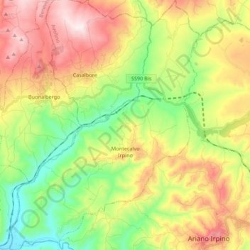
Name: Montecalvo Irpino topographic map, elevation, terrain.
Location: Montecalvo Irpino, Avellino, Italy (41.14681 14.95692 41.27093 15.08208)
Average elevation: 497 m
Minimum elevation: 165 m
Maximum elevation: 936 m
Make a donation
Gear up for your next adventure:
As an Amazon Associate, this site earns from qualifying purchases at no extra cost to you.