Geolocate

Montmajor topographic map

Click on the map to display elevation.

About this map
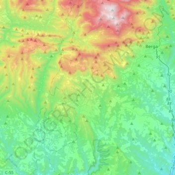
Name: Montmajor topographic map, elevation, terrain.

Location: Montmajor, Berguedà, Barcelona, Catalonia, Spain (41.93730 1.64425 42.15937 1.76498)

Average elevation: 845 m

Minimum elevation: 358 m

Maximum elevation: 2,077 m

Other topographic maps

Click on a map to view its topography, its elevation and its terrain.

Salselles

Spain > Catalonia > Berguedà > Borredà

Average elevation: 760 m

Serrateix

Spain > Catalonia > Berguedà > Viver i Serrateix

Average elevation: 659 m

l'Ametlla de Merola

Spain > Catalonia > Berguedà > Puig-reig

Average elevation: 410 m

Tubau

Spain > Catalonia > Berguedà > Sant Jaume de Frontanyà

Average elevation: 1,186 m

el Desert del Sàhara

Spain > Catalonia > Berguedà > Sagàs

Average elevation: 548 m

Gear up for your next adventure:

🧼Travel Hand Sanitizer - Keep hands clean when water is scarce
🥾Lightweight Hiking Shoes - Comfortable shoes for day hikes
🧢Outdoor Visor - Breathable visor for sunny hikes
🔥Emergency Fire Starter - Reliable ignition source for all weather conditions
⛺Lightweight Camping Tent - Portable shelter optimized for Canadian backcountry camping

As an Amazon Associate, this site earns from qualifying purchases at no extra cost to you.