Geolocate

Leymen topographic map

Click on the map to display elevation.

About this map
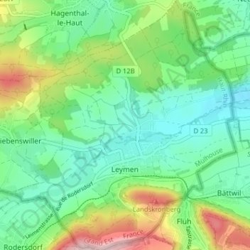
Name: Leymen topographic map, elevation, terrain.

Location: Leymen, Mulhouse, Haut-Rhin, Grand Est, Metropolitan France, 68220, France (47.48007 7.45464 47.52316 7.51118)

Average elevation: 397 m

Minimum elevation: 314 m

Maximum elevation: 584 m

Other topographic maps

Click on a map to view its topography, its elevation and its terrain.
Hexenmatten

France > Grand Est > Haut-Rhin > Leymen

Average elevation: 400 m

Gear up for your next adventure:

🥾Light Hiking Boots - Lightweight and comfortable boots for day hikes
🥾Approach Shoes - Shoes designed for climbing approaches and rugged trails
⛺Camping Essentials - All-in-one gear for a comfortable camping trip
🥾Waterproof Trail Shoes - Shoes designed to handle wet terrain
🧢Sun Hat - Wide-brim hat for sun protection

As an Amazon Associate, this site earns from qualifying purchases at no extra cost to you.