Geolocate

Lucas do Rio Verde topographic map

Click on the map to display elevation.

About this map
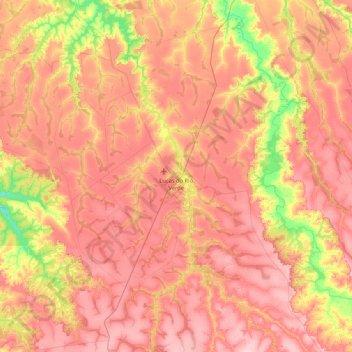
Name: Lucas do Rio Verde topographic map, elevation, terrain.

Location: Lucas do Rio Verde, Região Geográfica Imediata de Sorriso, Região Geográfica Intermediária de Sinop, Mato Grosso, Central-West Region, 78455-000, Brazil (-13.45791 -56.65900 -12.63812 -55.87421)

Average elevation: 394 m

Minimum elevation: 305 m

Maximum elevation: 458 m

Other topographic maps

Click on a map to view its topography, its elevation and its terrain.

2118,1 BZ Jauruzinho Sup

Brazil > Mato Grosso > Cáceres

Average elevation: 111 m

Gear up for your next adventure:

🔦LED Flashlight - Powerful and long-lasting flashlight for camping and emergencies
💧Reusable Water Bottle - Durable water bottles for hydration on trails
🥾Mountaineering Boots - Supportive boots for climbing and high-altitude hiking
🧦Merino Wool Socks - Moisture-wicking comfort for long-distance hiking
🥾Light Trekking Boots - Supportive boots for multi-day treks

As an Amazon Associate, this site earns from qualifying purchases at no extra cost to you.