Geolocate

Salento topographic map

Click on the map to display elevation.

About this map

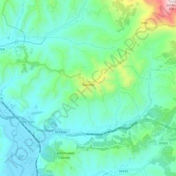
Name: Salento topographic map, elevation, terrain.

Location: Salento, Salerno, Campania, Italy (40.22627 15.12956 40.26804 15.22425)

Average elevation: 178 m

Minimum elevation: 8 m

Maximum elevation: 881 m

Other topographic maps

Click on a map to view its topography, its elevation and its terrain.

Marina di Vietri

Italy > Campania > Salerno > Vietri sul Mare

Average elevation: 141 m

Pogerola

Italy > Campania > Salerno

Average elevation: 363 m

Civitella

Italy > Campania > Salerno > Moio della Civitella

Average elevation: 614 m

Monte Cervati

Italy > Campania > Salerno > Sanza

Average elevation: 1,622 m

Catona

Italy > Campania > Salerno

Average elevation: 428 m

Iaconti

Italy > Campania > Salerno > Vietri sul Mare

Average elevation: 285 m

Erchie

Italy > Campania > Salerno > Maiori

Average elevation: 131 m

Ariano

Italy > Campania > Salerno

Average elevation: 281 m

Bosco

Italy > Campania > Salerno

Average elevation: 388 m

San Severino

Italy > Campania > Salerno > Centola

Average elevation: 273 m

Montepertuso

Italy > Campania > Salerno > Arienzo

Average elevation: 455 m

Gear up for your next adventure:

🔋Lithium AA Batteries - Long-lasting power that performs in extreme cold
🧭Orienteering Kit - Tools for map reading and navigation in the wild
🥾Waterproof Hiking Boots - Essential footwear for rugged terrain and wet Canadian trails
🔪Outdoor Multitool - Versatile tool for repairs and food prep in the wild
🕶️Polarized Sunglasses - Reduces glare from snow and water at high elevations

As an Amazon Associate, this site earns from qualifying purchases at no extra cost to you.