Geolocate

Finale Ligure topographic map

Click on the map to display elevation.

About this map

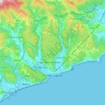
Name: Finale Ligure topographic map, elevation, terrain.

Location: Finale Ligure, Savona, Liguria, 17024, Italy (44.16022 8.27695 44.22060 8.41526)

Average elevation: 163 m

Minimum elevation: -1 m

Maximum elevation: 875 m

Other topographic maps

Click on a map to view its topography, its elevation and its terrain.

Cineplex

Italy > Liguria > Savona > Veravo

Average elevation: 421 m

Gear up for your next adventure:

🧢Beanie Hat - Keep your head warm in cold weather
🛶Kayak Accessories - Essential gear for safe and fun kayaking adventures
🛏️Sleeping Bag - Warm and compact sleeping bags for outdoor camping
🧦Hiking Liner Socks - Thin base layer to prevent friction and blisters
🕶️Polarized Sunglasses - Reduces glare from snow and water at high elevations

As an Amazon Associate, this site earns from qualifying purchases at no extra cost to you.