
Concord topographic map
Click on the map to display elevation.
About this map
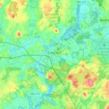
Name: Concord topographic map, elevation, terrain.
Average elevation: 54 m
Minimum elevation: 29 m
Maximum elevation: 115 m
Other topographic maps
Click on a map to view its topography, its elevation and its terrain.
South Chelmsford
United States > Massachusetts > Middlesex County > Chelmsford
Average elevation: 65 m
South Sudbury
United States > Massachusetts > Middlesex County > Sudbury > South Sudbury
Average elevation: 53 m
Haywardville
United States > Massachusetts > Middlesex County > Stoneham > Haywardville
Average elevation: 46 m
North Reading
United States > Massachusetts > Middlesex County > North Reading
Average elevation: 33 m