
Make a donation
Gear up for your next adventure:
As an Amazon Associate, this site earns from qualifying purchases at no extra cost to you.
Dover topographic map
Click on the map to display elevation.
Make a donation
Gear up for your next adventure:
As an Amazon Associate, this site earns from qualifying purchases at no extra cost to you.
About this map
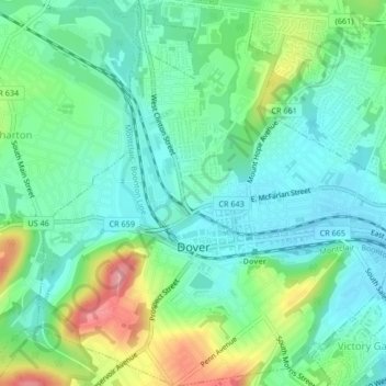
Name: Dover topographic map, elevation, terrain.
Location: Dover, Morris County, New Jersey, 07801, United States (40.87262 -74.57896 40.90411 -74.53811)
Average elevation: 205 m
Minimum elevation: 169 m
Maximum elevation: 289 m
Make a donation
Gear up for your next adventure:
As an Amazon Associate, this site earns from qualifying purchases at no extra cost to you.
Other topographic maps
Click on a map to view its topography, its elevation and its terrain.
Swinefield Bridge
United States > New Jersey > Morris County > East Hanover > Swinefield Bridge
Average elevation: 63 m
Butterworth Farms
United States > New Jersey > Morris County > Morris Township
Average elevation: 182 m