Geolocate

Calapan topographic map

Click on the map to display elevation.

Calapan

The overall land characteristic is a wide plain with rivers, interspersed with wetlands at the seacoast periphery. The highest elevation is 187 m (614 ft) above sea level at Bulusan Hill, a 6-kilometre (3.7 mi) long landform east of the city, which interrupts the mostly flat terrain north-east of the Halcon-Baco Mountain Range.

Wikipedia (CC-BY-SA 3.0)

About this map

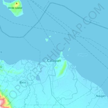
Name: Calapan topographic map, elevation, terrain.

Location: Calapan, Oriental Mindoro, Mimaropa, 5200, Philippines (13.29974 121.09781 13.56273 121.38291)

Average elevation: 12 m

Minimum elevation: -2 m

Maximum elevation: 843 m

Other topographic maps

Click on a map to view its topography, its elevation and its terrain.

Malitbog

Philippines > Oriental Mindoro

Average elevation: 18 m

Sinunoc

Philippines > Oriental Mindoro > Lantuyang

Average elevation: 111 m

Bucayao River

Philippines > Oriental Mindoro > Bucayao

Average elevation: 20 m

Bongabong River

Philippines > Oriental Mindoro > Lisap

Average elevation: 81 m

Naujan

Philippines > Oriental Mindoro

Average elevation: 252 m

Gear up for your next adventure:

🧭GPS Handheld Device - Reliable GPS navigation for outdoor adventures
🏕️Camping Hammock - Integrated protection for sleeping between trees
🔦LED Headlamp - Hands-free lighting for early morning starts or late finishes
🔋Emergency Crank Radio - Weather alerts and power without needing batteries
💧Hydration Bladder - Hands-free hydration solution for long treks

As an Amazon Associate, this site earns from qualifying purchases at no extra cost to you.